-

In this virtual exhibit experience, images of paintings are organized by which unit of the park they depict and are accompanied by the artist's stories. Photos and further information are included as a means of providing the viewer context for this collection of work.
-

Located in southwestern South Dakota, the lands within Badlands National Park have a rich and complex history. The Park is divided into three units: the North Unit, Palmer Creek Unit, and Stronghold District. The latter two together are commonly referred to as the South Unit. The following paintings depict landscapes from all three, and are divided by area with a map and description of the park unit.
-

The Stronghold Unit Marked by remnants of the gunnery range and crossed by just a few two-track roads of dubious nature, the Stronghold is not a place to journey on a whim. Those who do manage a visit are rewarded by vast expanses of prairie, creek beds that cut through the land, hidden springs, and fingers of erosion emanating from the handful of large sod tables. There are fields of undulating gray hills of the Chadron formation, balanced rocks that are remnants of river channels, and multicolored striations on long, roughly gouged expanses of eroding rock. Mixed amongst the beauty are remnants of the gunnery range: old car bodies and unexploded ordinance.
-

The Slide The Slide is the name for one of the park service access points into the Stronghold Unit. An old game trail, ranchers have used it for decades to move cattle up and down from the rim of Cuny Table. Traveling this steep and narrow route by vehicle requires a bit of nerve, though it is in relatively good shape having been recently improved with a layer of gravel. My first encounter with the slide was from the badlands floor, looking up. On another visit, led by an employee of OSPRA (Oglala Sioux Parks and Recreation Authority), we rode down from the rim via ATV. Driving up to the edge of the table and seeing this gate for the first time, I was struck by how well this one location epitomizes my south unit experiences. The immense spread of the badlands far below, the narrow and rugged "road" access, the unmarked fence that denotes an entrance point to a National Park. Not exactly welcoming, but mysterious and intriguing in an inviting way.
-

Heading West in Stronghold The two track paths through the Stronghold are clear and reasonably smooth in places, as shown here. I treasure the hours I've spent flying along these roads through the mystical prairie amongst the buttes and tables.
-

Leaving Stronghold After the Storm Somehow managing to miss the rains of every storm that passed over during this day's excursion, we were treated to a sudden warm glow on the distant badlands, starkly contrasted by menacing clouds rolling across the horizon. Earlier we had found a young foal trapped and in distress, its frantic mother on guard. Through perseverance and luck we were able to free the foal, thwarting the distant coyotes that howled through the process. In addition to this stunning view on our way out of the Stronghold, we witnessed a rainbow arching across the sky to touch the tip of Sheep Mountain Table.
-

Boundary at the 505 The 505 is one of the grazing districts within the Stronghold. It contains a variety of landscapes from jagged buttes to rolling chadron formations, prairie, creek crossings, and more.
-

Battle Creek with Plenty Star Table Battle Creek runs north/south through the heart of Stronghold, and the reasonably passable road crosses the creek bed numerous times. Some of these crossings are clear and passable, others pose serious risk, and still others have been abandoned in favor of a newer, less treacherous route. Driver beware: these abandoned paths are more visible than their replacements and can easily leave one stuck in the muck.
-

Badlands Bombing Range Deposition and Erosion During the use of the Badlands Bombing Range, old car bodies and large oil drums painted yellow were placed as targets for practice. Most of the oil drums have been removed during clean-up efforts, but old car bodies remain, dotted about the landscape within the Stronghold District. This unique specimen has been partially buried, or partially uncovered, by the forces of wind and water.
-

Bombing Range Legacy Another of the many car bodies places as bombing targets, this one is a favorite of one of my ranger friends, who dubbed it the "Bonnie and Clyde" getaway car. The day we visited it the sky was crossed by one storm after another and we were rained, hailed, and sleeted upon. Well worth it, though.
-

Cedar Creek from Blindman Table On one of my more adventurous excursions, my ranger companion and I accessed the area around Cedar Creek via a most unfriendly route. Often what looks like a passable road soon turns nasty. We spent as much time repeatedly getting the ranger truck out of the muck with a winch and deadman anchor as we spent getting into and out of the area. A week later I visited Blindman Table with another ranger friend, and from the distant heights was able to see the road we had been trying to access previously. It was in much better shape further north near Blindman than where we had been trying to pass through.
-

Life and Death at the Rim with Harney Peak I was initially surprised to discover that cattle and horses are allowed to graze within park boundaries in the South Unit. Grazing leases were made available to Oglala Sioux Tribe members on these lands that had previously been part of the Badlands Bombing Range. Finding this skull resting near the edge of the rim I was struck by its relationship to the new blades of spring grass and Harney Peak beyond. Harney Peak is a sacred location and at 7,242 feet it is the highest point between the Rocky Mountains and the Pyrenees.
-

Badlands Rim at Red Shirt Table Perhaps the best, though still remote, accessible location from which to view the immensity of the Stronghold unit is the overlook at Red Shirt Table along SD Hwy 40. Marked only by a small sign as you approach and a four post structure, this overlook is easily missed.
-

Stronghold View from Red Shirt Table A favorite Badlands view for many comes on the days when patches of cumulus clouds roll across the sky, casting waves of shadow upon the layers of buttes. This view of the Stronghold is from near the Red Shirt Table overlook.
-

Stronghold Table from Sheep Mountain Sheep Mountain Table is the one area within the South Unit that is readily accessible to visitors. This view is near what was called the Bombing Range Overlook, a place the military used to scout the planes targeting the land below as a practice bombing range. Following a rough dirt road to the top of the table, visitors can park, then hike several miles to the far edge of the table, a trek that yields the reward of a remarkable vista akin to that found at Bryce Canyon in Utah.
-

The Palmer Creek Unit Eroding northwards from a curved southern rim, the Palmer Creek badlands offer rock formations and deposition layers that are not found elsewhere within Badlands National Park. This is the most remote and inaccessible unit of Badlands National Park, with no public access. The few visitors who do gain access permission must hike many miles to reach the area and balance across a bridge consisting of two parallel I-beams. With little or no cell signal, visitors must be self-sufficient, prepared to deal with adverse conditions, unexploded ordinance, and any emergencies that may arise.
-

Palmer Creek After the Rain The story to this painting is a favorite. I was out with the chief ranger one day, exploring the Palmer Creek Unit. As the sun set, the truck became stuck in one of the many creek bed crossings: we'd missed the recent bypass meant to avoid the old and now impassable route. We were deep in the heart of Palmer, watching the sun set, waiting for our rescuer to locate us. Well after dark the truck was successfully winched out of the ditch. It ended well, but without the planned exploration of the area. One week later I returned with another ranger friend. We took the same route as the week before, but continued to the very end of the two track and then proceeded on foot, working our way through the slot canyon, further and further in and up until we were near the rim of Palmer Creek. It was a cold, muddy, rainy day, and as I took photographs of an impossibly mysterious landscape, my companion worked to scale a nearly vertical outcrop that was maybe 25-30 feet high. Upon reaching the top, he informed me that I must come up there with my "good" camera. After a most ridiculous series of attempts to scale the muddy, loose cliff with my heavy pack on, I had worked my way far enough that he was able to haul me the rest of the way up and over. This scene lay at our feet, surreal and awesome.
-

Hidden Monuments Exploring around the formations during my first visit into Palmer Creek, I wandered off alone for a time and followed a whim into an area that led back to this discovery. This formation felt immensely solid and as if it had been designed; a long forgotten castle or cathedral secretly eroding away. Simply spectacular.
-

Springtime Reflections During my first residency at Badlands, I was only able to reach Palmer Creek for one day. We found the location of an historic National Geographic paleontology dig from 1940 and the remains of tin cans and other waste left by the party. Exploring amongst the formations, I worked my way to this area to catch up with my friends who were exploring some interesting fossil finds, always careful to leave everything as they found it.
-

Erosion in the Palmer Creek Unit In this area there are scattered channels of erosion that cut deep below what feels like ground level, revealing the shape of the shelf-like formation of old river bed that I was walking upon. It made for an uneasy sense of my potentially precarious footing.
-

Rock Field in Palmer Creek This view shows the same distinct rock formation in the distance as in Springtime Reflection. Scrambling about these precarious rocks gave me the opportunity to examine the patterns of erosion and how the various rock formations have eroded and tumbled about each other.
-

Palmer Creek from the Rim I spent a day with two ranger friends, driving along the rim of Palmer Creek, peering into the depths below, and continually trying to keep myself oriented. I was able to spot distinct buttes that I knew from my visits to the badlands floor, and we located the area where the slot canyon is that led up to the scene in Palmer Creek After the Rain. The saddle shaped formation near the center of this painting is in the far distance of the photographs I took while stranded with the chief ranger far below.
-
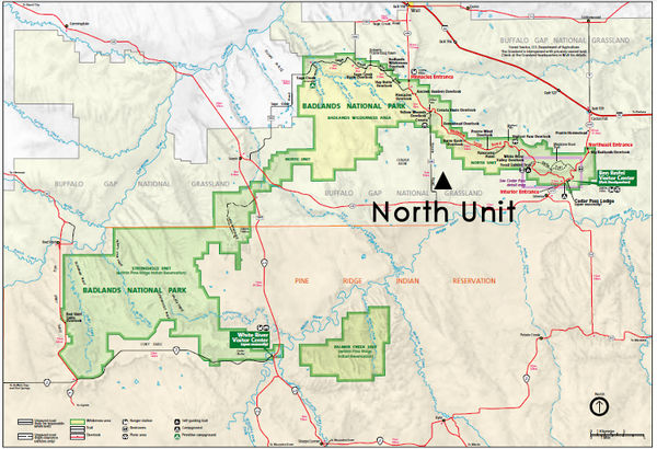
The North Unit Offering splendid vistas of surprising diversity, the North Unit contains by far the most accessible regions within Badlands National Park. The Badlands Loop Road, Hwy 240, winds its way through the eastern half of the north unit and is dotted with scenic overlooks and hiking trail access points. The road traverses several passes down and back up the badlands wall, presenting views from both the rim and the floor far below. While many visitors choose to witness the scenery as an optional bypass to I-90, it is well worth the time to stop for at least a few of the overlooks, and take a walk along a trail or two. More adventurous visitors may wish to take a back country hike and/or plan an overnight stay. A drive west along Sage Creek Rim Road, a well maintained gravel road, brings visitors into the Sage Creek Wilderness Area which is home to the park's bison herd and multiple prairie dog towns. Other wildlife is found in abundance if you visit during the right time of day. Wherever you go within the North Unit, you will be treated to stunning views of landscapes and wildlife, along with the joy of being in nature. Remember to have sufficient food, water, and gas for your visit; clean drinking water is available only at the visitor center.
-

Vampire Peak I photograph these buttes nearly every day when I'm in the park. Something about them and the sweeping sea of grasses that lead to them has enchanted me. I was pleased to discover that the larger butte here is Vampire Peak, a formation frequently noted in old photographs for its distinctive set of tall rocks balanced on top, which have since eroded away.
-

Angel Butte in Snow Located behind the Visitors Center, Angel Butte is easily visible from the row of park ranger apartments I have lived in during my time as Artist-in-Residence. Light does enchanting things to these buttes, particularly at sunrise and sunset. The morning after a fierce blizzard during one of my stays, I awoke early, bundled up, and tromped out to watch this sunrise on Angel Butte.
-

Sage Creek in Spring The Sage Creek Wilderness Area is home to the park's bison herd, and contains an unimproved campground. During my first residency, I camped here with a group of high school students from the Calhoun School in NYC who were visiting the park with their teacher, a former AiR for the park. In the morning, as the students were lingering over breakfast and breaking down camp, I set out for a little solo hike. Not far from the campground, over a few small hills and near Sage Creek, I found the carcass of a recently deceased bison. This explained the tremendous chorus of coyotes we had heard the night before. Bringing the students to view this find, we also ventured down into the creek bed to examine the fossils to be found in the calcite concretions within the Pierre Shale. This painting is from that day's experience, the clouds sweeping through the vivid blue sky, the strength of the prairie, and the patient rocks waiting to be discovered.
-

Calhoun Canyon: End of the Beginning On the last day of the Calhoun School's first visit to Badlands, we set out for a day of hiking and exploring. One of the teachers wanted to hike into this area near Saddle Pass, thinking there might be a way to get back into some of the canyons. He was right, and we found a path through a narrow slot canyon that ended in a bowl shape about 30 feet below the rim above. Another teacher discovered a way to scramble up some brush to a cliff with some good foot holds, and we all climbed our way up and over the edge of the rim. Here there were more tall buttes ahead. We unofficially dubbed the canyon "Calhoun Canyon" in honor of the Calhoun School students and teachers who may have been the first to find and explore its depths.
-

On the Rocks: Above Calhoun Canyon After climbing over the rim at the top of Calhoun Canyon, we explored amongst the rocks and buttes, later learning that we were very close to the Castle Trail. I returned to this location several times, and on a particularly brilliant day found these balanced rocks, which intrigued me with their vivid mix of colors contrasted by the shadows of a midday sun and clouds sweeping by overhead.
-

Above Cedar Pass An adventurous four hour hike led my companion and I to the highest point in the Cedar Pass area, at the very top of the buttes that rise above the Notch Trail, high above the Cliff Shelf Nature Trail. From here we could see for miles past the town of Interior. Eagle Nest Butte rose in the distance on Pine Ridge Indian Reservation, turkey vultures soared below us, and the Visitors Center and park housing area were reduced to pinpoints beneath our feet. On the hike out, we passed through the area shown in this painting.
-

Saddle Pass Area Buttes rising from the sea of prairie grasses is a classic vista within Badlands National Park. The area near Saddle Pass is rich with this experience, and passing clouds bring shadows that offer contrast to the layers of pale rock.
-

Badlands Prairie Known for their rough buttes and rock formations, the Badlands are also home to a large amount of mixed grass prairie. Visiting my grandparents' farm in central Minnesota as a child, I developed a strong affinity for rolling plains, seas of grass with vast skies above. This landscape never fails to bring a sense of peace and fullness.
-

A Tribal National Park Site of the proposed first Tribal National Park, one wonders what Stronghold and Palmer Creek Units may look like in the future. As many have said before about similar areas of natural beauty, it seems a shame to pave roads through these ruggedly beautiful environments. Such roads seem less effective at showcasing the landscape here than in the North Unit. In the initial scouting of the South Unit by the National Park Service and Oglala Sioux Tribe back in the late 1960s, a scenic drive was proposed near the rim along Cuny Table, and another along the rim of Palmer Creek. These could work well, with limited overlooks to give visitors a chance to stop and take in the scenery. In Stronghold, a hiking trail or two leading down to the floor below could be breathtaking, perhaps interpreting how Stronghold was a refuge for the survivors of Wounded Knee. There may even be a bison herd roaming the land here someday. Isolated as the Palmer Creek Unit is, it is difficult to imagine an easy solution to the issue of tourist access. In the end, aside from a rim road, this area may be best maintained as a remote wilderness, perhaps someday with public road access on top, and a parking area for hikers who wish to explore below the rim. However the details are worked out, great care must be taken to find a balance between allowing visitors a chance to embrace this cultural landscape and maintaining its pristine nature. photograph of the Stronghold ©2013 Jessica L. Bryant
-

South Unit History Part 1 Called Mako Sica by the Oglala, the lands encompassed by the Stronghold and Palmer Creek Units of Badlands National Park have a rich and complex history. Originally wide open to the people inhabiting the region, these lands provided refuge for Lakota people who were pursued by the U.S. Calvary during the "American Indian Wars." As the borders for Pine Ridge Indian Reservation were defined and redefined, these rough and intimidating labyrinths of erosion were of little interest to early Westerners. But when the United States Army Air Force had need of a bombing range during WWII, the US viewed the badlands within Pine Ridge Indian Reservation with new interest as a suitable place for bombardier training. Mako Sica was home to more than 125 families who were quickly displaced to make room for an aerial bombing range, leaving some families homeless. Residents were given little notice to vacate their homes and relocate cattle. Entire communities like Potato Creek were condemned and removed. photograph of the Stronghold ©2012 Jessica L. Bryant
-

South Unit History Part 2 Following WWII, the Badlands Bombing Range was declared excess property by the U.S. Government, but few were able to regain their former lands. Most families couldn't afford to buy their lands back from the government, and Tribal, U.S., and State agencies were quick to propose different ideas for the former bombing range. In 1968, Congress authorized a land swap between the Departments of Defense and the Department of Interior, creating the South Unit of what would become Badlands National Park, and returning the rest of the aerial bombing range to the Oglala Sioux Tribe. The land exchange was ultimately approved by the Tribe because if not approved, the entire bombing range would have been disposed of as surplus property. photograph of the Stronghold ©2012 Jessica L. Bryant
-

South Unit History Part 3 Today most of the South Unit is owned by the Oglala Sioux Tribe and co-managed by the National Park Service. Cattle grazing leases on the South Unit provide some revenue, although this practice may change as the Park and Tribe study reintroduction of bison into the South Unit. Another proposal would separate the South Unit from Badlands National Park and create a new National Park - the nation's first ever "Tribal National Park." photograph of the Stronghold ©2012 Jessica L. Bryant
-

South Unit History Part 4 There are a few means of visiting the South Unit that are reasonably accessible to most visitors. A trip to visit the White River Visitor Center during its open season is well worth the time. Sheep Mountain Table is accessible by most vehicles and provides sweeping views after a hike of several miles. Please contact the park for more information. Remember to do your research and be prepared. Always respect the rights and privacy of neighboring landowners and obtain proper permissions where needed prior to attempting to access areas within the South Unit. Keep in mind that unpaved roads become impassable during and after rain and snow. Bring sufficient food and water for your visit and fill up on gas; the nearest services may be an hour or more away. Take care that someone knows your plans. And always remember to never touch or step on metal objects; unexploded ordinance is an ever-present danger. photograph of Sheep Mountain Table ©2013 Jessica L. Bryant
-

Experiences of an Artist-in-Residence "My first encounter with Badlands National Park occurred in March 2012 as I entered the park coming from Wall. My residency was to start the next day, and I was very excited to be there. Driving the loop road through the North Unit of the park was like entering a magical world. This landscape was largely why I chose to apply to Badlands for a residency, and I began to fall in love right then."
The Artist-in-Residence (AiR) program at Badlands National Park was founded in 1996 and is open to all professional artists. Writers, composers and all visual and performing artists are invited to interpret this wind-swept environment through their work. The program provides time for artists to get away from everyday responsibilities and focus on their surroundings and their medium. The program is made possible by the support of the park's cooperating association, Badlands Natural History Association. photograph ©2013 Gary Joseph Cohen -

"When I first arrived at Badlands, the South Unit was talked about with a certain mystique. I only knew a couple rangers who had ever been there, and many who had never experienced any areas outside of Sheep Mountain. During the off-season, there are few people in and around the park, making it easier to get to know more individuals. I was fortunate to make friends with several rangers and was offered opportunities to tag along during on-duty explorations as well as venture out with friends on their days off. These circumstances led to my initial opportunities to learn about and explore the South Unit. Before coming to the park, I had read brief references to the Stronghold Unit, but there was no real information on visiting any area besides Sheep Mountain. At the park, what I heard from rangers was that you really can't access other areas within the South Unit. You need to know the neighboring land owners and receive permission to cross into the park. I had dismissed the possibility when one day a ranger friend offered to take me into the South Unit on his day off. It was an incredible experience, and left me hungry to see and learn more." photograph of the Stronghold ©2012 Jessica L. Bryant
-

The Artist-in-Residence Program This Triptych, The Three Units of Badlands National Park, was Jessica's donation to the park following her first residency.
Artists have long had an impact on our perceptions of national parks. In the American West, painters and photographers documented spectacular landscapes for audiences who had never seen such sights. Dramatic photographs, paintings, and descriptive essays helped to stimulate the establishment of many national park areas and continue to foster an appreciation of them today. Artists ranging from painters to musicians to poets continue to interpret the living landscape through motion and emotion using contemporary approaches and techniques. Our program's goal is to provide an avenue for artists to translate preservation of this place into images that evoke responses in those who may never visit Badlands National Park. -

Artists at Badlands are provided on-site housing, a small stipend, and six weeks of time to explore the park. In return, they present educational programs at local schools and donate an original work to the park's collection.
In the spring 2012 during her first residency at Badlands National Park, Jessica worked with the students of nearby Interior School, grades K-8th. Teaching drawing and watercolor painting, Jessica guided the students through the process of creating their own representations of landscapes from within the North Unit of the park. The completed paintings were used to create this compilation poster. -

In the fall of 2012 Jessica returned to Badlands for a second residency. The the park asked her to spend one week teaching landscape painting to 59 students at Red Cloud High School on Pine Ridge Indian Reservation. This endeavor laid the groundwork for long term partnership opportunities with the school, reached out to local Lakota youth, and instilled stewardship ethic and appreciation of BNP resources. A large portion of the park is located on the reservation and is co-managed by the Oglala Lakota Tribe and the National Park Service.
-

Thank you for viewing this exhibit. If you would like to read more about Jessica's experiences as an artist in residence at Badlands National Park, visit her blog where she has maintained daily posts for each of her residency experiences.
For further information on Badlands National Park, visit their website at www.nps.gov/badl. photograph of the Palmer Creek Unit ©2013 Jessica L. Bryant